Showing 298 items matching history - gold mining
-
 Stawell Historical Society Inc
Book, R.B. Watchorn, A Pictorial History of Gold Mining at Stawell Victoria - Previously Cat No 3632, 1986
... A Pictorial History of Gold Mining at Stawell Victoria... grampians Book A Pictorial History of Gold Mining at Stawell ...stawell -
 Lions Club of Maldon Inc.
Document, The History of Dragline Gold Mining Bucket Dredge at a site on Bendigo Road
... The History of Dragline Gold Mining Bucket Dredge at a site... Document The History of Dragline Gold Mining Bucket Dredge ... -
 Unions Ballarat
Ballarat Trades Hall Eureka Flag, 1942
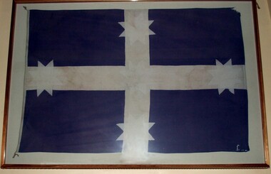
... eureka rebellion trade unions - history gold mining - ballarat ...This flag originally flew from the flagstaff on the Trades Hall Building in Camp Street Ballarat on December 3rd 1942. The flag prompted many enquiries to the Ballarat's Courier newspaper. The Courier in reporting that the flag was, in fact, a replica of the original Eureka Stockade flag went on to say that: "… it (seemed) very strange that the town in which Eureka made a name for Australia and its efforts to get freedom from control for the ordinary man, did not recognise the flag that flew while the first move for freedom was fought out against big odds." The Trades Hall Eureka flag, made of cotton material, was used in union marches during the 1940s. In later years it had been all but forgotten, until in 1981 it was brought to the office of the then MHR for Ballarat, John Mildren by members of the family that the flag maker had boarded with in Ballarat. David Miller, who had a keen interest in the Eureka story and was electorate officer for John Mildren, became custodian of the flag for many years and presented it to Ballarat Trades Hall for display. In 1994 The Ballarat Trades Hall Eureka flag travelled Australia as part of a touring Eureka collection. At that time, the Secretary of the Ballarat Regional Trades and Labour Council, Graeme Shearer said “…The Eureka flag then, as it does now, symbolises the struggle for basic rights and democracy”. On Wednesday 11th July 2001, following a ceremony to mark the refurbishment of the Galloway Monument, the Ballarat Trades Hall Eureka flag was unveiled at a function in the Ballarat Trades Hall by President of the Ballarat Trades & Labour Council, Rhonda Young, and Premier of Victoria, Steve Bracks. The Trades Hall gratefully acknowledges the assistance of Dean Mighell, then Victorian State Secretary of the CEPU/ETU - who was a passionate supporter of the diggers' stand at Eureka - and instrumental in making funds available to assist in Trades Hall's Eureka flag being mounted in the Main Hall of the Ballarat Trades Hall. As far as we know, this is the second oldest Eureka flag in the world. Union (especially Ballarat Trades and Labour Council) history and Eureka Stockade - Ballarat.Flag; blue background; white embellishments - cross and stars; framed.btlc, ballarat trades hall, ballarat trades and labour council, mildren, john, miller, david, southern cross flag - btlc, eureka rebellion, trade unions - history, gold mining - ballarat, gold miners, eureka flag - btlc -
 Unions Ballarat
The astonishing history of Ballarat 1851-1855, Bradby, Doug, 2018
... History - gold mining... to the history of Ballarat, gold mining, Sovereign Hill and the Eureka ...Chapters Chapter 1. 1848-50. The Discovery of Gold in the Port Phillip District. How a shepherd found Victoria’s first gold but failed to produce a goldrush. Chapter 2. The Discovery of Gold in Victoria. How a publican, a squatter, some more shepherds, a doctor, and an ex mailman, found the gold that produced the Victorian goldrush. Chapter 3. The Discovery of Gold at Ballarat. How the Ballarat gold field was discovered by Thomas Hiscock at Buninyong, and by old John Dunlop and young James Regan at Poverty Point, and by Old Tom Brown of Connor’s Party at Golden Point. Chapter 4. The Genesis of Ballarat. How the diggers arrived, mined, lived, and governed themselves at Ballarat. Chapter 5. The Exodus from Ballarat. Why the diggers left Ballarat when they had found less than 1% of Ballarat’s gold. Chapter 6. The Monster Nuggets. Why Sarah Sands from Ballarat was introduced to Queen Victoria at Windsor Castle. Chapter 7. Settling Down on Ballarat. How and why some diggers settled permanently at Ballarat as miners. Mining in the year of Eureka. How the miners tackled the problems of shepherding and the mining consequences of the Eureka Stockade. Chapter 8. The Gravel Pits. How the miners of Ballarat Flat learnt to work ‘in the water.’ Chapter 9. Towards the Tableland. What the miners did when they hit a ‘wall of rock.’Relevance to the history of Ballarat, gold mining, Sovereign Hill and the Eureka Stockade.Paperback book; 176 pages. Front cover: red background; illustration of miners in white; author's and illustrator's names and title. btlc, ballarat trades and labour council, ballarat trades hall, history - ballarat, history - gold mining, eureka stockade -
 Orbost & District Historical Society
book, Club Terrace, 2009
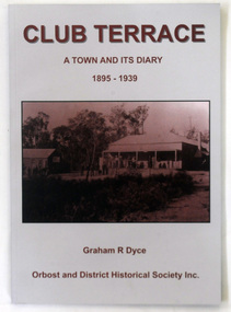
... club-terrace-history-settlement gold-mining... author, Graham Dyce. club-terrace-history-settlement gold-mining ...This book was published by Orbost & District Historical Society in 2009 after the death of Graham Dyce in 2007. Graham Dyce was a long-time member of Orbost & District Historical Society. His family came from the Combienbar / Club Terrace district.This is a local history book written by a local author, Graham Dyce.A 144 pp book titled Club Terrace, A Town and its Diary 1895-1939. It has a grey and sepia cover with a sepia photograph of The club Terrace Hotel.The book was written by Graham Dyce.club-terrace-history-settlement gold-mining -
Clunes Museum
Functional object - GOLD SCALES, W. & T. AVERY LATE T. BEACH. BIRNINGHAM ENGLAND. METAL BOX FOR WEIGHTS MANF. BY BELL & BLACK LONDON
... WITH THE VIEW TO PRESENT THEM TO THE MUSEUM. local history scales gold ...THESE GOLD SCALES WERE GIVEN TO THE MUSEUM BY MRS. JOAN SANDWITH. HER HUSBAND DON BOUGHT THEM WITH THE VIEW TO PRESENT THEM TO THE MUSEUM.GOLD SCALES ON WOODEN BASE WITH DRAWER. INCLUDING METAL BOX FOR WEIGHTS. ALSO CONTAINING GOLD DUST, DUSTER AND SMALL WEIGHT. 13 ITEMS IN TOTALlocal history, scales, gold, mining -
Unions Ballarat
Australian history: The occupation of a continent, Mellor, Suzanne, 1978
... - indigenous gold mining - ballarat eureka stockade ballarat reform ...Australian history includes coverage of: Indigenous matters; white settlement; Macquarie; convicts; immigration; pastoral era; politics; gold rush; unions; identity; federation; wars; the great depression.Treatment of issues relating to the Ballarat Reform League and the Eureka Stockade. One chapter covering craft unions, unskilled workers, Trades Halls, women's issues, industrial action, and ALP and unionism.Paperback; yellow with black lettering; 411 pages.Front cover: title and authors' names Title page: the name CULNANE has been written in red.btlc, ballarat trades hall, ballarat trades and labour council, history - australia, history - ballarat, history - indigenous, gold mining - ballarat, eureka stockade, ballarat reform league, unions - history -
 Marysville & District Historical Society
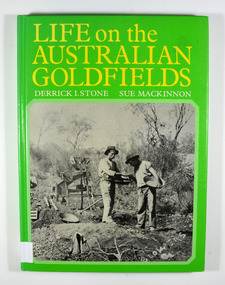
Book - Hardcover book, Life on the Australian Goldfields, 1984
... A history of gold mining in Australia... Society / P.O. Box 22 / Marysville 3779 A history of gold mining ...A history of gold mining in AustraliaHardcover. Front cover has a photograph of two miners from West Australia using the dry-blowing technique. In the background are two 'Wood's dry placer-miners'. Back cover has a photograph of the interior of a steam-operated quartz crushing battery at the Mount Boppy Mine.Front cover has a price sticker that is discolored. Inside there is the stamp of the Marysville & District Historical Society / P.O. Box 22 / Marysville 3779 gold, gold mines, gold mining, australia, history, social life, customs, stone, derrick i, mackinnon, sue -
Koorie Heritage Trust
Book, Banfield, Lorna L, Like the ark : the story of Ararat, 1955
... | Gold mines and mining -- Victoria -- History | Colonisation... -- Ararat -- History | Gold mines and mining -- Victoria -- History ...A history of the settlement of Ararat by one of the descendants. Most references to Aboriginal people in Chapter IV (scattered references elsewhere). Early relations between Kalkadoondeet (Kalkatungu) and Jajowurrung (Djadjawurrung) people and settlers. Violence and retribution reulting from tensions over the grazing and destruction of settlers, sheep and cattle which had overrun their waterholes and hunting groungs. Numbers and names of some Aboriginal people killed in the Ararat region. Establishment of rival 'sheep stations' by the Djadjawurrung people led by King Billy Billy.202 p. :ill ; 22 cmA history of the settlement of Ararat by one of the descendants. Most references to Aboriginal people in Chapter IV (scattered references elsewhere). Early relations between Kalkadoondeet (Kalkatungu) and Jajowurrung (Djadjawurrung) people and settlers. Violence and retribution reulting from tensions over the grazing and destruction of settlers, sheep and cattle which had overrun their waterholes and hunting groungs. Numbers and names of some Aboriginal people killed in the Ararat region. Establishment of rival 'sheep stations' by the Djadjawurrung people led by King Billy Billy.ararat (w vic sj54-08) | western district (w vic sj54-07) | king billy billy | pioneers -- victoria -- ararat -- history | gold mines and mining -- victoria -- history | colonisation | food | settlement and contacts - settlers | race relations - violent - massacres, murders, poisonings etc. - to 1900 | economic sectors - agriculture and horticulture - pastoral industry - sheep and wool | djadja wurrung / dyadyawurrung / dja dja wrung people (s31.1) (vic sj54-04) -
Koorie Heritage Trust
Book, Bowden, Keith MacRae, Goldrush doctors at Ballaarat, 1977
... Victoria -- History. | Gold mines and mining -- Victoria... Victoria -- History. | Gold mines and mining -- Victoria ...An historical account of events and doctors during the goldrush era at Ballarat.xiii, 125 p. : ill. (part col.), map ; 1977An historical account of events and doctors during the goldrush era at Ballarat. doctors. victoria. ballarat. gold fields, 1850-1860. | physicians -- ballarat, victoria -- history. | gold mines and mining -- victoria -- ballarat. -
Unions Ballarat
Deeper Leads: New Approaches to Victorian Goldfields History, Reeves, Keir, 2007
... of the goldfields' history. Relevant to the history of gold mining ...This book fills some gaps in the narrative of goldfields' history. The author addresses social and cultural significance of the goldfields' history.Relevant to the history of gold mining in Australia.Paper; book. Front cover: background is black and white. Picture of soil horizons.Front cover: title and editors' names.btlc, ballarat trades hall, ballarat trades and labour council, australian history, goldfields, gold, gold mining, social history, eureka stockade -
Clunes Museum
Book, PINNACLE PRINTING CO. PTY.LTD, VICTORIA 150 YEARS OF GOLD, 2001
... BOOK GOLD MINING GOLD MINING HISTORY PINNACLE PRINTING CO ...GOLD COVERED BOOK - VICTORIA 150 YEARS OF GOLDlocal history, document, book, gold, mining, gold, mining, history -
 Marysville & District Historical Society
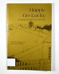
Book - Paperback book, Happy-Go-Lucky-A Gippsland Gold Town 1863-1917, 1987
... A history of a gold mining town in the Gippsland area...://users.netlink.com.au/~maptrap A history of a gold mining town in the Gippsland ...A history of a gold mining town in the Gippsland area of Victoria Paperback. Gold cover. Cover has a pencil sketch of a gold mining town as well as a large gum tree on the back cover. Cover illustration runs across the whole cover.Stamp of the Marysville & District Historical Society Inc / P.O. Box 22 / Marysville 3779. Sticker - DISTRIBUTED BY: / Paoletti's (Adventurer) Maps P/L / 15 Nirvana Close, / Langwarrin. 3910 / Tel: 03 9789 6985 / Fax: 03 9776 6798 / Email: [email protected] / Other products & information Website: http://users.netlink.com.au/~maptrapgold, gold mining, gold town, gippsland, victoria, australia, history, gold miner, morgan, dorothy, morgan, marjorie -
 Ballarat Tramway Museum
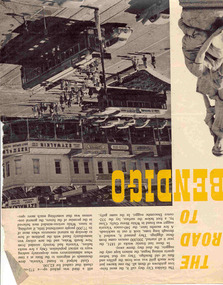
Newspaper, The Walkabout Magazine, "The Road to Bendigo", Oct. 1974
... , gold mining days and other information, including three..., gold mining days and other information, including three ...Yields information about the final day of the Bendigo tramways and some of the tramcars used.Three double sided sheets from "The Walkabout" magazine, October 1964, titled "The Road to Bendigo". Five printed pages featuring photographs of Bendigo, its buildings, its history stories, gold mining days and other information, including three illustrations containing trams. .1 - Charing Cross with bogies and single trucker - taken early 1960's. Photo by A. Doney. Features the intersection, with Ezywalkin store. Note the "Jeffrey's bread" roof advertisement on the single trucker. .2 - Bogie tram on the Eaglehawk route prior to any nearby housing development - reclaimed mining land - has Castrol roof advertisement - photo by Claver P Carroll. .3 - No. 6 outside The Beehive stores - 3BO - photo by Claver P Carroll. bendigo, eaglehawk, charing cross -
 Federation University Historical Collection
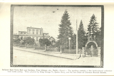
Book, Guide to Ballarat the Beautiful, 1923
... . Themes include: Ballarat History pre gold, mining, Eureka...: Ballarat History pre gold, mining, Eureka Stockade, Lake Wendouree ...The image of Ballarat Trustees relates to a building on the corner of Mair and Lydiard Streets. In 2010 it was used as Cuthberts law firm.Grey/green soft covered book. Includes photographs and map. Themes include: Ballarat History pre gold, mining, Eureka Stockade, Lake Wendouree, South Street, Grand National Eisteddfod of Australasia, schools, Black Hill, Lake Burrumbeet, Creswick, Buninyong. Illustrations and advertisement include: Sturt Street,James Smith, Ballarat Town Hall, Ballarat East Town Hall, Rowlands, Ballarat brewing Co., Royal Standard Brewery, steam train, Lake Wendouree, J.S. Vickery & Son, trout, Berry, Anderson & co., Ballarat Botanical Gardens and hot houses, Claxton Memorial Fountain, statues, New Imperial Gold Mine, Art Gallery of Ballarat, St Patrick's College, Ballarat Grammar School, Ballarat School of Mines, Ballarat College, Sunnyside Woollen Mills, Ballarat Agricultural High School, Passenger Steamer on Lake Wendouree, Moorabool Falls, Lal Lal Falls, Grosvenor Square, Netherby, Buninyong, Ballarat Motor Garage.ballarat, cuthberts, ballarat trustees, sturt street, tram, trams, ballarat town hall, crag's hotel, sun foundry, eureka aerated waters and brewing co, d. lem, chinese practioner, chinese herbalist, hugh v. mckay, sunshine harvester, gordon brothers, central business college, george hotel, edwards pyrites furnace, long's biscuits, ballarat eisteddfod, george farmer, ballarat botanical gardens, eureka stockade, lake wendouree, ballarat school of mines, moorabool falls, kirks reservoir, ballarat post office, hepburn lagoon, star of the east mine, emu river, ballarat observatory, statues, angus' rialto cafe, carlyon's hotel, clarendon ladies' college, j.e, sang, ballarat coffee palace, stansfield and smith, ballaray brewing company, phoenix brewery, rotal standard brewery, john macleod co, robert sim and co, cobb and co\eagle foundry, j.j. goller and co., mt buninyong lookout, ballarat town hall ballarat east gardens, hot house, glass house, statuary pavilion new imperial gold mining co.,, art gallery of ballarat, st patrick's college, ballarat agricultural high school, lake wendouree steamer, grass trees at mt clear, mount clear, lake burrumbeet, newlyn reservoir trout, lal lal falls, grosvenor square, netherby, ramelli's motor garage, buninyong gold obelisk, memorial, imperial gold mine, botanical gardens lily pond and fernery -
 Ballarat Tramway Museum
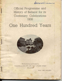
Book, Editor William H. Rees, "Official Programme and History of Ballarat for its Centenary Celebrations 1938 / One Hundred Years", 1938
... of Ballarat gold mining, water, supply and other services...., the history of Ballarat gold mining, water, supply and other services ...Book with 124 pages, missing original covers, titled "Official Programme and History of Ballarat for its Centenary Celebrations 1938 / One Hundred Years", comprising 8 signatures and side and stapled with three staples along the left hand side. Price 1/- Features photographs of the city (images 2 and 3), Editor's Foreword, message from the Mayor J.H. Trekardo, a listing of daily events for each month in the history of the Ballarat and the year of the event, eg on page 20, August 18, "Electric Trams service commenced, 1905". Has many advertisements from local businesses, including the SEC (image 4) on page 25, the history of Ballarat gold mining, water, supply and other services."Edward Crimmins" on the top right hand corner of page 1 in ink. See Reg Item No. 2488 for a signature on the Membership receipt for H.P. James 1939 - Treasurer? of the Ballarat Historical Society.trams, tramways, ballarat, centenaries, civic history -
 Bendigo Historical Society Inc.
Photograph - Victoria Hill, Bendigo, 1973
... of Bendigo’s gold mining history and the importance that mining played... of Bendigo’s gold mining history and the importance that mining played ...Gold was discovered on Victoria Hill in 1854 and by 1861, 1,200,000 ounces of gold had been extracted from the site. The first claim was bought for 80 pounds by Prussian immigrant Christopher Ballerstedt and his son Theodore. Christopher Ballerstedt was nicknamed the "Father of the Hill" and was the first to prove that gold reefs extended below the surface. His 200-foot plus mine shafts yielded quartz rich with gold, inspired other miners, and were instrumental in Bendigo becoming the world's deepest and richest goldfield. The site still features relics of nineteenth century mining including quartz crushing machinery and the foundations of George Lansell’s 180 mine. These features are characteristic of Bendigo’s mining history and represent two prominent nineteenth century miners, Christopher Ballerstedt and George Lansell, who held important roles in the development of Bendigo. Victoria Hill Quartz Gold Mines are registered as a site of significance. The site is of historical, archaeological and scientific importance to Victoria. The mines represent the symbolic heart of Bendigo’s gold mining history and the importance that mining played in wealth creation and the development of Victoria. The diggings reserve is accessed from the rear of Albert Richardson Reserve located at 40-56 Marong Road, Ironbark. The site has steep and unformed paths and is closed to the public at dusk. It is important to stay to the paths to avoid the diggings. Interpretive signs help visitors to appreciate the importance of the site and the remaining relics of Bendigo’s mining history.Victoria Hill Ironbark, Bendigo. Photos of the poppet head, sand heap, tailings, shafts and tunnels. Before development into a tourist attraction.history, bendigo, victoria hill, ironbark, diggings -
 The Beechworth Burke Museum
Photograph - Photograph - Reproduction, c.1870s
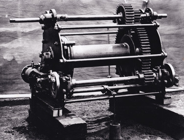
... This photograph shows a piece of gold mining equipment.... Throughout the history of mining for gold and other precious ...This photograph shows a piece of gold mining equipment identified as a mine winch, possibly an air winch cylinder of 1870s RG Ford's Patent design. Throughout the history of mining for gold and other precious materials, the windlass or winch (pictured) was used to bring up buckets full of soil from the bottom of a mine. This soil was then searched for gold/metals before being relocated to a different area. Due to the size and complexity of this particular piece of equipment, this winch may have been used to raise and lower mine carts to the entrance of the mine (often used in coal mining) and could have been used in raising cages up and down (acting as elevators) containing miners if the mine was particularly deep. The actual use of this particular item in the Beechworth locality is undocumented but these are some possibilities based on the use of these pieces of equipment in other mining locations. Mining can have a largely detrimental impact to the environment and therefore, the study of machinery like the one depicted in this photograph can help researches to reconstruct the methods and technologies used in the late 1800s and early 1900s. This particular item appears to have been removed from it's original site where it would have been used to assist with mining. It is possible that this photograph has been taken for recording purposes or as part of a machinery exhibition. Prior documentation records that this piece of equipment had connections to the Rocky Mountains Mining Company. Today, the Rocky Mountains Gold Mining company is famous in Beechworth for having been instrumental in the creation of the Rocky Mountain tunnel. Construction for this tunnel began in 1859 when a group of 12 men blasted a 400ft long tailrace though the rock beneath the town of Beechworth. Today, the 800ft tunnel, completed in 1871, is a popular tourist attraction but during the decades of gold mining, the purpose of this tunnel was to divert water away from the main sluicing operations so miners could better access gold and precious materials. The tunnel was used for this purpose for many years, later becoming useful for the Zwar Brother's tannery and currently as an outfall drain for Lake Sambell. This area continued to be mined until the early 1900s. The period when this item was in use is unclear but it is estimated to have been in the 1870s based on the design and appearance of the image. The gold works at the Rocky Mountain Tunnel closed in the early 1920s but the impact of mining remains in Beechworth today and therefore the study of photographs like this one which contain mining equipment can further understanding of mining in this region.This photograph has historic and research potential for study on the gold mining of the Beechworth region and types of equipment used to locate gold after the initial gold rush of 1853-1854 which resulted in the discovery of the surface gold and required miners to dig deeper to access precious metals. The clarity of the photo, and its good preserved condition, means it can continue to be used for research. This photo is part of a collection of six photos all within the Burke Museum Collection which depict mining equipment.Square black and white photograph on card.7793.1beechworth, mining, goldmining, goldmining equipment, beechworth burke museum -
 The Beechworth Burke Museum
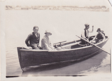
Photograph, 1920
Taken in 1920, depicted are four people in a rowing boat on Lake Sambell, Beechworth. From left to right, it is believed that the names of the people are Eric Beard, Mrs Doris Beard, and S/L to Bert Beard. The last two figures are unknown. Lake Sambell is a beautiful Victorian recreation lake and urban park with a unique history. It was created in the mid-1800s by the Rocky Mountain Mining company during the gold rush era and used as a mining site until the early 1900s, which brought Europeans into the area. It was turned into a reserve for residents in 1920 and is considered an icon of Beechworth as it represents the development of the community, human endeavour, and the spirit of the landscape.This photograph represents the community's social use of the lake in 1920.Black and white rectangular photograph print on paper.Reverse: LAKE SAMBELL/ c 1920/ from LTOR/ 1 ERIC? - BERT'S SON/ 2 MRS DORIS BEARD/ 3 S/L TO BERT BEARD/ 4 #beechworth, lake sambell, lake sambell boating, beechworth lake, social, 1920, victoria -
 The Beechworth Burke Museum
Photograph, Unknown
Aerial view of Lake Sambell, Beechworth with town views. Lake Sambell is a beautiful Victorian recreation lake and urban park with a unique history. It was created in the mid-1800s by the Rocky Mountain Mining company during the gold rush era and used as a mining site until the early 1900s, which brought Europeans into the area. It was turned into a reserve for residents in 1920 and is considered an icon of Beechworth as it represents the development of the community, human endeavour, and the spirit of the landscape.This photograph represents Lake Sambell with town views.Black and white reproduced rectangular photograph print on paper.Reverse: Stampbeechworth lake, lake sambell, aerial photo, construction, australian landscape, #beechworth, victoria -
 The Beechworth Burke Museum
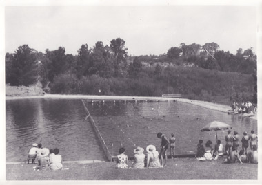
Photograph, 1960s
Taken in the 1960s, depicted are approximately twenty-nine male and female spectators at a school swimming carnival on Lake Sambell near the caravan park. Lake Sambell is a beautiful Victorian recreation lake and urban park with a unique history. It was created in the mid-1800s by the Rocky Mountain Mining company during the gold rush era and used as a mining site until the early 1900s, which brought Europeans into the area. It was turned into a reserve for residents in 1920 and is considered an icon of Beechworth as it represents the development of the community, human endeavour, and the spirit of the landscape. This photograph represents the post-gold rush era use of Lake Sambell as a recreational reserve. Swimming carnivals were held at the lake and considered a social event for the Beechworth community.Black and white reproduced rectangular photograph print on paper.Reverse: Community/ Swimming pool 1960s/ near the caravan park/ Lakes?lake swimming pool, lake swimming, beechworth carnival processions, carnival, #beechworth, beechworth 1960s, victoria -
 The Beechworth Burke Museum
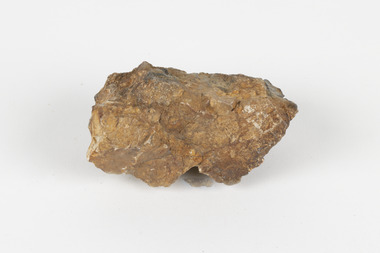
Geological specimen - Cassiterite
This specimen is Cassiterite in Quartz. Cassiterite is a tin oxide metal that forms in thin crystals which can have a beautiful lustre. Quartz is made of silicon dioxide, also known as silica, and is one of the most common minerals on earth. Cassiterite has been a fundamental source of tin ore for humans throughout history, including today. Tin is an important metal that has a wide variety of human uses in different areas, from dying fabric, to making mirrors, and their most well-known use ‘tin’ cans. Tin cans are primarily made of steel and are coated with tin in order to take advantage of tin’s property of being non-corroding. This is a massive step in the history of food preservation. Tinned food first reached Australia in 1815 with early settlers, and it began to be manufactured here in the 1840s. It was incredibly popular, and was a highly exported product, which would be a contributing factor to the ‘tin mining boom’ of the early 1880s. This specimen was collected at Jingellic, New South Wales, in about 1852. Although the Goldfields of the 1800s are much more well-known, tin mines existed alongside the gold mines which began in the mid 19th century and extended almost one hundred years, to the mid 20th century. Specimens like this would have been used as evidence to justify tin mining operations in the region as an investment. This specimen is part of a larger collection of geological and mineral specimens collected from around Australia (and some parts of the world) and donated to the Burke Museum between 1868-1880. A large percentage of these specimens were collected in Victoria as part of the Geological Survey of Victoria that begun in 1852 (in response to the Gold Rush) to study and map the geology of Victoria. Collecting geological specimens was an important part of mapping and understanding the scientific makeup of the earth. Many of these specimens were sent to research and collecting organisations across Australia, including the Burke Museum, to educate and encourage further study. The Geological Survey of Victoria was headed by British geologist, Alfred Richard Cecil Selwyn (1824-1902), who was responsible for issuing over 60 geological maps during his 17 years as director. These maps were all hand-drawn and coloured and became the benchmark for accuracy for geological mapping. Collecting geological specimens was an important part of mapping and understanding the scientific makeup of the earth. Many of these specimens were sent to research and collecting organisations across Australia, including the Burke Museum, to educate and encourage further study. A fist-sized solid geological specimen made on one half of tin oxide, which is dark grey, and on the other side of silica, which is brown and cream.burke museum, beechworth, geological, geological specimen -
 The Beechworth Burke Museum
Photograph, Unknown
... history colonial australia australian gold rushes mining ...The A1 Gold Mine is located north of Woods Point, near Jamieson, in the Upper Goulburn region of Victoria. Gold was discovered at the A1 site in 1861 and mining operations began in 1864. The A1 Mine Settlement refers to a small township known variously as Castle Reef, Castle Point, and Raspberry Creek, which developed in the 1860s around mining industry centred on a crushing machine that worked the three gold reefs in the area. Historically, the name "A1"referred to the high quality of gold found in the quartz reefs at depths of at least two thousand feet. Along with the Morning Star mine at Woods Point, the A1 gold mine produced almost sixty percent of Victoria's gold output in the 1950s to 1970s and continued operating until 1992 when it went into administration. Operations at the site were revived in 2016 and the A1 Mine is now considered one of Victoria's premier gold mines. The A1 mine is part of the extensive and prospective Lachlan Fold Belt, a north-west trending belt of tightly folded Early Devonian sedimentary rocks extending from New South Wales to Victoria. Mineralisation is hosted within or immediately adjacent to diorite dykes. Contemporary development of the 'Queens Lode' at the A1 mine signals a move from high-grade, narrow vein airleg mining into larger scale, mechanical mining designed to increase ore production volume. This original, undated photograph of the A1 Mine appears to depict an area or phase of disuse or abandonment. The aged and humble appearance of the cottage suggests association with the historical A1 Mine Settlement, therefore the image may have been taken prior to the 1950s-1970s revival period in which the A1 mine is known to have produced high gold yields. The photograph contributes to our understanding of the A1 Gold Mine's impact on the landscape and the social, environmental impacts of mining on communities and may be compared with others in the Burke Museum's extensive collection of mining photographs to deepen our understanding of mining in the Jamieson area.Black and white rectangular photograph printed on photographic paperReverse: 5577 / A1 Mine / Near Jamieson / Vic. /burke museum, beechworth museum, beechworth, gold fields, gold rush, victorian gold rush, mining tunnels, gold ming history, colonial australia, australian gold rushes, mining technology, beechworth historic district, indigo gold trail, indigo shire, upper goulburn shire, jamieson, woods point-walhalla goldfield, a1 gold mine, victorian high country, modern mining methods, orogenic gold province, gold mineralisation, devonian, dykes -
 The Beechworth Burke Museum
Photograph - Photograph - Reproduction, ca. 1900
... gold mining history... gold mining gold mining history ...This image shows the approach to Beechworth from the south-west via the Newtown Bridge. Numerous early buildings line the road as it bifurcates to become Ford and High Streets on the ridge above Spring Creek and Newtown Falls. The sloping, rocky terrain and water course along the gorge show evidence of the intense mining activity that occurred at the site. The Ovens Gold Rush at Beechworth started when gold was found at Spring Creek in February 1852, prompting an influx of miners from around the world. The population grew over 20,000 by 1857. While the earliest mining at Beechworth was similar to that in other Victorian goldfields like Ballarat and Bendigo, Beechworth is notable for its use of hydraulic sluicing as a major method of removing wash-dirt. Hydraulic sluicing employs high pressure jets of water to blast away large areas of earth and wash it down to be run through a sluice box. Gold gets caught in the sluice and the remaining slurry is washed away. This method of mining is extremely effective but causes significant environmental impacts and damage to waterways. Large water quantities were required for large-scale sluicing, and the long water races and deep tailraces that were constructed in the Beechworth area in the nineteenth century are nonetheless considered feats of engineering. The site in the photograph is associated with the Rocky Mountain Mining Company who constructed an eight hundred meter tunnel under the township between 1876-1880 to reduce water levels at Spring Creek, which had been subject to diversions since the earliest days of alluvial mining. Over four million ounces of gold (115 tones) were found at Beechworth between 1852 and 1868, and the wealth from the gold rushes built Beechworth and the nationally significant buildings that remain standing today.This image shows the early development of the Beechworth township above Spring Creek, where gold was discovered in 1852. Evidence of hydraulic sluicing, a uniquely predominant method at Beechworth, and water-works engineering are present in the landscape. By the 1870s, alluvial gold deposits were depleted and increasingly complex engineering was required so deeper shafts could reach bedrock. This image is significant for understanding changes to the landscape and the evolution of mining methods and engineering practices related to the extensive construction, manipulation and management of water networks. The shift from smaller scale alluvial mining to larger company dominance in the mining industry has implications for understanding wider social, economic, political and industrial changes in the region of Beechworth and within the context of the Victorian Gold Rush more broadly. A black and white rectangular reproduction photograph printed on photographic paper. burke museum, beechworth museum, beechworth, gold fields, gold rush, victorian gold rush, hydraulic sluicing, rocky mountain mining company, spring creek, netwown falls, mining tunnels, water races, tailraces, colonial australia, australian gold rushes, mining technology, beechworth historic district, indigo gold trail, migration, indigo shire, gold mining, gold mining history -
 The Beechworth Burke Museum
Photograph - Photograph - Reproduction
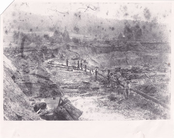
This photograph depicts mining operations within the Beechworth area, in an unidentified valley where sluicing was utilised as a method for extracting gold from the environment. After gold was discovered in the region in 1851, sluicing became a characteristic of gold mining in the region - "Ovens miners carved intricate networks of races" throughout the region - involved the diversion of water in many channels, or water races, which contained inbuilt 'ripple devices' designed to trap gold for later extraction. By 1871, 900 miles of water races had been cut into the Beechworth Mining District. As suggested by the numerous figures involved in labouring along the water race, sluicing was a source of considerable employment within the region. This image is of important historical significance for its ability to convey information about sluicing and the methods used to find gold in the 1850s, and provides clues as to how sluicing and the widespread construction of water ranges changed the environment of the region. This image is important for current research into the history of the Ovens region in Victoria, which played such a prominent role in the early Australian gold mining industry. Therefore, this image has the capacity to be beneficial for research into society and the motivations of those living and working in this region during this period and therefore, has social significance. The Beechworth Burke Museum has additional images relating to gold sluicing and and the mining activities in the area more generally, which can be analysed and studied alongside images like this one.A black and white rectangular photograph printed on matte photographic paperbeechworth, mining, miners, labour, water race, sluicing -
 The Beechworth Burke Museum
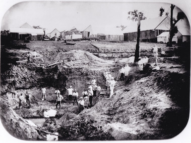
Photograph - Photograph - Reproduction
After gold was discovered to be deposited "for miles along Woolshed Valley" in the early 1850s, the Woolshed became a major site of mining activity in the north-east . This region was divided into large claims of 80 yards long, one of which was the one depicted in this photograph, called 'Big Johnson's Claim'. Claims such as this utilised a range of technology, including water wheels, steam engines, sluices and toms, most of which would not arrive until after 1856 when this photograph was taken. The Woolshed initially became prosperous in 1855, and labourers, such as the ones depicted in this photograph, engaged in sinking work for 7 pounds a week, whilst other mining labourers could earn up to nine. The search for gold is ingrained into the history of Victoria and therefore, images like this one which portray an open cut sluicing site can reveal important information for society and technology for the date when the photograph was taken. This image is of important historical significance for its ability to convey information about the operations of mining claims, particularly of the Woolshed Valley area that this photograph documents. This image is important for current research into the history of Woolshed, which was a major site of mining significance and operations. Therefore, this image has the capacity to be beneficial for research into society and the motivations of those living and working in this region during this period and therefore, has social significance. The Beechworth Burke Museum has additional images relating to gold sluicing and the Woolshed area which can be analysed and studied alongside images like this one. A black and white rectangular photograph printed on matte photographic paper.Reverse: 7791 / page 34. / 52% / Big Johnstone / Claim on Woolshed Goldfields / 1856 / Note canvas [illegible] building / Burke Museum /woolshed, mining, claims, mining claims, big johnson, gold -
 The Beechworth Burke Museum
Photograph - Photograph - Reproduction
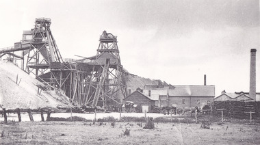
This photograph depicts the Great Southern Mine located in Rutherglen as it was during the 1900. After the initial Gold Rush of 1853-1854, Gold was discovered deeper under the surface of the earth in the 1860 after the discovery of another deep lead system. Due to the discovery of Gold in Rutherglen, Rutherglen developed into a community in its own right, possessing a population of 6600 by December 1860 and developed into a municipality in 1862. The Great Southern Mine depicted in this photograph required the use of a range of modern technologies, including the hydraulic pumps, in order to reach gold. This photo depicts the mining operations as they were undertaken around the turn of the century.The search for gold is ingrained into the history of Victoria and therefore, images like this one which portray a modern mining operation undertaken in the 1860s, can reveal important information for society and technology for the date when the photograph was taken. This image is of important historical significance for its ability to convey information about the methods used to extract gold in 1900. It is significant as most mining operations around the region, particularly earlier on in the period, used different technologies such as water races. This image is important for current research into the history of Rutherglen more generally, a town which developed singlehandedly due to the discovery of minerals and mining, as depicted here in this photograph, thus indicating an element of social significance as well as historic. The Beechworth Burke Museum has additional images relating to mining and Rutherglen which can be analysed and studied alongside images like this one.A black and white rectangular photograph printed on matte photographic paper.Reverse: $ 3.00 19972503 / a02503 / Great Southern Mine Rutherglen 1900rutherglen mine, rutherglen, great southern mine, beechworth, mine, mining, post goldrush, victoria, gold, 1860s, sluicing, hydrolic sluicing -
 The Beechworth Burke Museum
Photograph
The photograph, captured around 1900, depicts a large group of minors located in Beechworth. Importantly, this photograph can provide information into the clothing and fashion of minors during this period of history. These men wear loose fitting shirts which are mostly a pale white colour, several wear vests and/or jackets and loose fitting trousers with boots. The majority of men wear wide brimmed hats to protect their skin and eyes from the sunlight. One man has a wooden pipe in his mouth and a few have ties/neckerchief's tied around their necks. The outfits of these miners has the potential to provide insight into their social status, these men are all dressed equally which provides the notion that they are of equal societal standing. The outfits of these miners dating to the 1900s is not dissimilar to photographs of those captured in the 1880s. The location of this photograph is not easy to interpret, but the photograph is recorded to have been taken in the Beechworth region. Displayed in this image is some wild shrubbery and grass where the men are standing/sitting and behind the group is a tin wall or even tin building. At the end of 1899, companies were continuing to search for gold in Beechworth and the surrounds but these attempts were not overly successful. In the early 1900's Quartz mining was occurring but this was done by individuals or smaller parties. It is unclear if these men are mining for gold or for quartz.The search for gold is ingrained into the history of Victoria and therefore, the study of images like this one which portrays some of the miners who worked behind-the-scenes for these discoveries has the potential to reveal important information regarding society, fashion etc. The date when the photograph was taken is vague but it allows us to form a timeline of mining activities in the North East. This image is of important historical significance for its ability to convey information about society at the time, regarding fashion (which can potentially reveal social status) and mining in Beechworth in 1900. Black and white rectangular photograph printed on matte photographic paper mounted on board.Reverse: BMM 8032/ Group(?) Beechworth Mines about 1900/ 80quartz, north east gold, sluicing, gold sluicing, hydraulic sluicing, mining, gold mining, north-east victoria, beechworth, burke museum, 1900, group, miners, hats, vests, ties, wild shrubs, tin, quartz mining -
 The Beechworth Burke Museum
Photograph - Photograph - Reproduction, Unknown
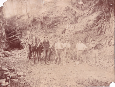
This image is a reproduction of an 1899 original depicting the 'Williams Good Luck Mine' on the Mopoke Reef (also called 'Morepork Gully') in the Dingle Ranges, approximately three miles from Beechworth. The foreground of the image is littered with piles of smashed rock and detritus, known as ‘mullock’, beside a reinforced mine shaft, a vertical access passageway allowing miners to enter the mine and haul ore out using lifting technology such as a poppet heads, whims or windlasses. A group of miners and a dog appear close to an open-sided miner’s hut. Following the discovery of gold at Beechworth in 1852, rushes quickly followed at surrounding creeks and gullies in the district. In the late nineteenth and early twentieth centuries, small syndicates of miners continued to work old or abandoned quartz reefs, often persisting without the assistance of heavy machinery to remove the large amounts of rock, in order to obtain yields at ever greater depths. The group of miners in this photograph are Mr. Roger Williams and Sons, who revived operations at the ‘Old Good Luck’ mine on the Mopoke Reef in the Dingle Range near Beechworth around 1892, working the site for more than two decades. An emigrant from Cornwall with experience in the tin mining industry, 19 year old Roger Williams senior sailed to New Zealand in 1840, then to Australia where he spent time in the Bendigo Gold Fields before settling in Beechworth in the early 1860s. Mr Williams senior worked on various mining activities in the district, including the Rocky Mountain Tunnel project. Conversant with the character of gold-bearing reefs in the area, the syndicate dug an eight hundred foot tunnel, digging down as far down as two hundred feet with little capital save their labour, to connect and provide better working access to the mass of reefs and veins in the vicinity. Progress was hampered by poor air quality charged with fumes from dynamite and large quantities of rock had to be crushed to obtain payable yields. The Victorian Goldfields are filled with ruins and remnants of the area's rich mining history, ranging from small alluvial diggings to the remains of huge mining companies. Site names often changed several times throughout the nineteenth and twentieth centuries. Some sites were abandoned and forgotten, others were worked continuously over many decades. The names of mines were often repeated at different locations throughout the Victorian Goldfields. For example, there is a Mopoke Gully heritage mine near Fryers Creek, Victoria. 'Mopoke' is a common onomatopoeic name for Morepork and Australian Boobook owls. This image has historical, social and research significance for patterns of emigration during of the Victorian Gold Rush, and the historical, social and environmental impacts of mining at Beechworth at the turn of the nineteenth and twentieth centuries. As gold became scarce and government support and large company investment waned, poor hard-working miners laboured intensively to make a living through periods of high unemployment. This image can be compared and studied alongside other historical mining photographs and objects in the Burke Museum Collection. It has potential to improve our understanding of miners working conditions and the shifting character of mining in the Beechworth district. Black and white rectangular reproduction photograph printed on matte photographic paper.Obverse: Williams Good Luck Mine Beechworth / Roger! / Reverse: 6858 / burke museum, beechworth museum, beechworth, gold fields, gold rush, victorian gold rush, gold ming history, colonial australia, australian gold rushes, mining technology, beechworth historic district, indigo gold trail, migration, indigo shire, good luck gold mine, victorian goldfields, mining syndicates, gold fever, quartz-mining, small-scale mining, old good luck mine, mopoke gully, quartz reefs beechworth -
 The Beechworth Burke Museum
Photograph
This photograph depicts a reef mine in Beechworth. Reef mining, or quartz reef mining, was common in 19th Century Victoria. This gold mining technique requires mine shafts to be sunk into underground quartz reefs, with horizontal tunnels dug from the original shaft at differing levels to find the gold-bearing rock. The quartz would then be hoisted to the surface, which would then be pounded to access the gold in its metallic state. Gold was discovered in Beechworth in February 1852, at Spring Creek. Within 11 months of that discovery, over 8000 hopeful prospectors quickly descended on this region, transforming it into a thriving, wealthy township. Reef mining and hydraulic sluicing were gold mining techniques used in this region in the 19th and early 20th centuries. This photograph interestingly contains dogs alongside the miners. While dogs have been recorded as deterrents to thieves in the Victorian goldfields, these dogs appear as companions to these men.The search for gold is ingrained into the history of Victoria and therefore, images like this one can reveal important information for society and technology for the date when the photograph was taken. It also shows a location where reef mining was undertaken which provides insight into the impact on the environment at a time when it was done. Although quartz is one of the most common minerals found in the earth's crust, it does not always contain gold. Those reefs that do are rare and highly sought after by prospectors. The Beechworth Burke Museum has additional images relating to gold mining which can be analysed and studied alongside images like this one.Sepia coloured rectangular photograph printed on gloss photographic paper. Obverse: Reverse: United Shire of Beechworth/ Shire Secretary/ Reef Mining, Beechworth./ 6167.abeechworth, burke museum, gold, gold mining, gold rush, victorian gold rush, reef mining, quartz, companion dog, horse and cart